
How can you hike safely - from day hike to thru-hike?

Staying safe and minimizing risk on trails in the wilderness or National Parks should be the no.1 consideration, as well as enjoying the beautiful scenery and keeping fit.
Even on a "day hike" you should be prepared to spend the night outdoors in an emergency or something unexpected like a sudden storm.
For solo female hikers, exploring the wilds of nature can be awe-inspiring but also sometimes risky. If you are at the wrong place at the wrong time, the consequences can be awful - a sudden slip or a maniac lurking in the woods who is seemingly a friendly fellow hiker. See Murder on the Appalachian Trail
Preparing before you go and carrying a few crucial items in your pack can make the difference between life and death in some situations. These items can protect you and fellow hikers from the environment, help you find your way back home, and signal for help. In most cases, you’ll never need them and may you think you’ll save the weight and leave items at home, think twice, as you never know what mother nature can throw at you.
Basic Safety tips for hiking trips
Leave your hiking itinerary with friends or family
You should let somebody you trust, such as family or a close friend, know where you are going, how long you plan to be away, and when you are due back.
Remind them to inform the authorities that you are missing if you are not back by a specific date, with a degree of leeway.
Don’t hike alone if you can, and don’t separate the group
Hiking in a group makes you less vulnerable to animal attacks, serial killers, or other unsavory people you might meet on the trail. There have been many stories of hikers disappearing when they get left behind, either because they have been injured or decided to wait for the rest of the group. So always keep the group together where you can.
Stories where hiking or hunting groups were separated that led to disaster include:
The strange disappearance of George Penca in Yosemite National Park
The strange disappearance and death of Todd Hofflander in Hells Canyon
The Strange disappearance of Connie Johnson from Big Fog Mountain
The Strange Disappearance and death of Aaron Hedges in the Crazy Mountains (Member only)
Carry the right gear
It can be a difficult balance to know how much gear to carry on a hike. It’s obvious that for dedicated thru-hikes on trails like the PCT (Pacific Crest Trail) or the A.T. (Appalachian Trail) much more basic equipment would be needed than an overnight trip in Yosemite or the Scottish Highlands.
The general advice is that for longer trips, go with a pack that weighs less than three pounds (1.36 kg), with a carrying capacity of no more than 65 liters.
Signaling and communication
Be prepared that you may not have a signal when outdoors with your cell phone. A mirror and a whistle attract attention and don’t need a battery or a cell signal. Mirrors can reflect light to helicopters or planes in a search operation, and whistles can be heard from some distance away to attract attention. Both are small and lightweight.
Clothing
Hypothermia can happen, and even a warm day can turn cold at night, especially at altitude. Sweating through exertion can also contribute to a drop in body temperature as the air temperature falls. A lot of body heat is lost through the head, and wearing a hat can help keep warm. Wearing a base layer mid-layer and carrying or wearing jackets appropriate for the time of the year and location are vital.
Food and water
Bring enough food for at least 1-2 days. Energy bars and dried meals are light and easily carried in a pack.
Water is vital as many streams in the wilderness can be contaminated with bacteria or parasites and need to be made safe with chlorine tablets or filtration systems or boiling water for several minutes. Extra water is vital, especially in hot or humid weather, as death from dehydration can occur in several days.
Carry a map and compass or a GPS
It’s easy to get lost in the wilderness by missing the correct fork in a trail or getting disorientated by dense forest. Carrying a map and compass or GPS is a good idea and may help you find your way back to safety. However, simply having them is not enough. You need to know how to use them. Basic info on how to use a GPS is essential. Note, though, that a map and compass do not run out of batteries and never have "zero signal".
Fire starting
Carry something to start a fire, including a firestarter, matches, a lighter or flint and a striker.
As well as warmth and cooking, fires can be used to let searchers know where you are, especially in open ground and can warn off animals. Smoke from a fire can be a daytime signal, and the firelight can be seen at night very clearly. If you can find some dry material to burn, the fire can continue for many hours.
Ideally, and especially on longer trips, you should carry, at a minimum, a fire starter and a Ziploc bag of lint or cotton balls to get the fire going.
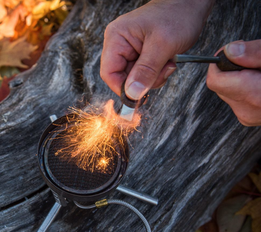
Commercial kits are also available, e.g. LightmyFire FireLighting Kits uses a Swedish FireSteel firestarter made from a durable magnesium alloy, which produces 3,000-degree concentrated sparks. It contains The Tinder-on-a-Rope, 80% resin content, sustainably sourced, natural fire tinder,
Pocket or Swiss-army knife

A good knife can help with building a shelter and food preparation. Small utility tools, called Swiss Army knives, have many Tools. Small, medium and large Swiss knives are available with more tools as the size increases. For example, the medium-size Victorinox Pioneer X Alox Limited Edition 2021 has a large blade, scissors, reamer, can opener, screwdriver 3 mm, bottle opener, screwdriver 7.5 mm, wire stripper and a keyring.
First aid kit
First aid kits can now be purchased, which weigh very little and can be vital in an emergency, and they can be essential on overnight or multi-day hikes. They can also be built item by item, or there are commercially available kids online. You should minimize bulk and weight by carrying the smallest containers
Good items to pack in your first aid kit:
Dressing/Gauze – Sterile non-stick absorbent for larger wounds
Medical Tape – Lightweight, breathable surgical tape for blisters and cuts
Hand sanitizer
Antiseptic wipes - Cleaning wounds.
Butterfly closure strips
Antibiotic Ointment
Pain killers e.g. Ibuprfoen.
Antihistamine tablets – For bites and allergic reactions.
Duct tape –for any repairs.
Sewing needle and Safety pins– For slings.
Card with emergency contact and any important personal medical information.
Shelter
If you are not taking a tent with you, It can be an excellent idea to carry some plastic sheeting to create a tarp cover over a shelter or a portable shelter if you run into trouble. Creating an emergency shelter to stay warm and dry can be critical to survival.
Carrying some materials that can be fashioned into a shelter is an easy way to minimize risk in the wilderness, even on a short trip. Being prepared to stay overnight, even if you are only being out a few hours, is a good way to help survive an emergency on the trails.
Personal locator beacon
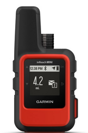
A personal locator beacon made by companies like Garmin (e.g. Garmin InReach), can be used to summon help in an emergency. Suppose you push the "SOS" button. In that case, a signal is sent via satellite to a dispatch center that knows your location, some identification information, and that you have an emergency. Dispatch will contact local resources such as the National Park Service in the United States.
The SOS messages that devices send are received and handled by companies like GEOS Inc., a for-profit, private-sector entity that specializes in various forms of remote emergency dispatch. Most personal locator devices use GEOS dispatch services. The speed, type, and viability of local response depend on the weather, available resources, and other potential emergencies in the area.
Other items
Trash bag
Pack a few clear plastic bags as they can be useful to keep things dry, collect fire-starting materials and so on.
Headlamp (or flashlight)
Heat-reflecting emergency space blanket
A firearm - Although the law allows registered users to carry firearms on some major trails like the Appalachian Trail from Georgia to Main, in compliance with federal, state, and local laws, the authorities discourage hikers from doing so. If you choose to carry a gun, check out the concealed carry laws for each state, you’ll be passing through and have any essential permits.
Report suspicious activity or hikers to the authorities
If you spot anything unusual or suspicious, report it to the local rangers or police. It may save someone else’s life if not your own!
Sign in and shelter and visitor log books
You should write your real name or trail name at each shelter or guest book that you come across. That way, the National Park Service (NPS) or other park service, depending on where you live, can notify family members when they inform the authorities that someone has gone missing. The NPS has warned against providing too much personal information as these details can make hikers, particularly women, more vulnerable to attack.
Keep in touch
Keep your loved one’s or friends’ minds at ease by checking in and communicating regularly. If you’re not one for phone calls or texts, the Cairn app can be handy. It’s a great app built for hikers that automatically alerts a hand-selected group of people called a “safety circle.” The app allows real-life location tracking, and it can send auto-alerts to your safety circle in case you miss a pre-scheduled check-in time.
Cairn has been named one of the three best map apps for navigating the wilderness by Outside Magazine.

GET FOUND IF YOU’RE OVERDUE
• Notifications: Safety contacts are notified when you’re past due
• Live tracking: Contacts can see your GPS location during your trip or hike
• Rescue advice: Contacts get important info needed to make intelligent rescue initiation decisions
STAY CONNECTED IN THE OUTDOORS
• Know where others have found cell coverage
• Download maps that are designed specifically for outdoor pursuits
• Send status updates with a single tap
SEE TRAIL STATS
• Get live distance, elevation gain and ETA stats for 4000+ hiking routes, summits, and trails worldwide
• Customize your ETA stat based on your activity type (hiking, running, skiing, horseback riding, snow travel, mountain biking) and speed
• Record and save your trail while you hike
If you plan on being in an area with low cell coverage, consider opting for a Personal Locator device.
Exclusive articles for members of StrangeOutdoors that are not available elsewhere on the site.
See the latest Exclusive members-only articles on StrangeOutdoors.com
Read more Q&A’s on StrangeOutdoors
Weird vibes in the wilderness - what causes them?
What happens when a human body decomposes?
How is Forensic genealogy helping on wilderness disappearance cold cases?
Why are people found in the backcountry with their clothes missing?
What are good books and audiobooks on missing people in the great outdoors?